.png)
Satellite Oil Spill Monitoring UAE: Seeing the Threat Before It Reaches Our Shores
- ESS TEAM
- Mar 1
- 5 min read
Updated: Jun 3
The Arabian Gulf does not forgive slow responses. One of the world's most strategically important bodies of water, the Arabian Gulf supports critical energy infrastructure, some of the busiest shipping lanes on the planet, and a significant share of global oil exports. Protecting it requires constant vigilance. For oil spill risk, that vigilance is increasingly coming from space.
At Falcon Eye, our monitoring operations have provided a unique view of just how persistent and complex oil spill activity across the Arabian Gulf can be. Across sustained monitoring engagements in the Arabian Gulf, our satellite surveillance team has issued hundreds of operational reports tracking oil anomalies from initial detection through trajectory evolution and eventual closure. Features have been detected across a wide geographic range — from the upper Gulf near major Iranian export infrastructure, through Bahraini waters, to the approaches of major UAE ports and as far as the Gulf of Oman near Fujairah. Some anomalies measured less than a square kilometre. Others exceeded 125 square kilometres. None reached UAE shores as a major environmental incident. That outcome was not accidental.
The Problem No Coastal Radar Can Solve
Traditional maritime surveillance is built for vessels and weather — not for the slow-moving, often invisible threat of surface oil. A spill originating hundreds of kilometres offshore is beyond the range of shore-based observation. By the time it becomes visible to the naked eye or detectable by conventional monitoring, a response window has already been lost. For a port operator, an environmental agency, or a maritime authority, that is the difference between pre-positioned resources and a crisis.
The Arabian Gulf compounds this challenge. Its enclosed geography, strong tidal currents, and extreme traffic density create conditions where oil released at one end can migrate steadily toward critical infrastructure at the other. Kharg Island remains one of the world's most significant crude oil export hubs, handling vast volumes of oil destined for international markets. The potential for spillage, whether through operational discharge, vessel incident, or infrastructure failure, is not a theoretical risk. It is a persistent operational reality.
Intelligence, Not Data
Falcon Eye operates three independent satellite sensor types: Sentinel-1 Synthetic Aperture Radar, which detects oil through changes in sea surface backscatter in all weather conditions, day and night; Sentinel-2 optical imagery at 10-metre resolution for visual confirmation and precise extent mapping; and Landsat 8-9 for additional independent corroboration. When multiple sensors detect the same feature independently, confidence in the detection increases substantially — two entirely different physical measurement principles converging on the same location is compelling evidence.
But detection alone is the beginning of the service, not the end. What matters operationally is not that oil is on the water somewhere — it is where that oil is going, how fast, and whether it will reach an asset of consequence.
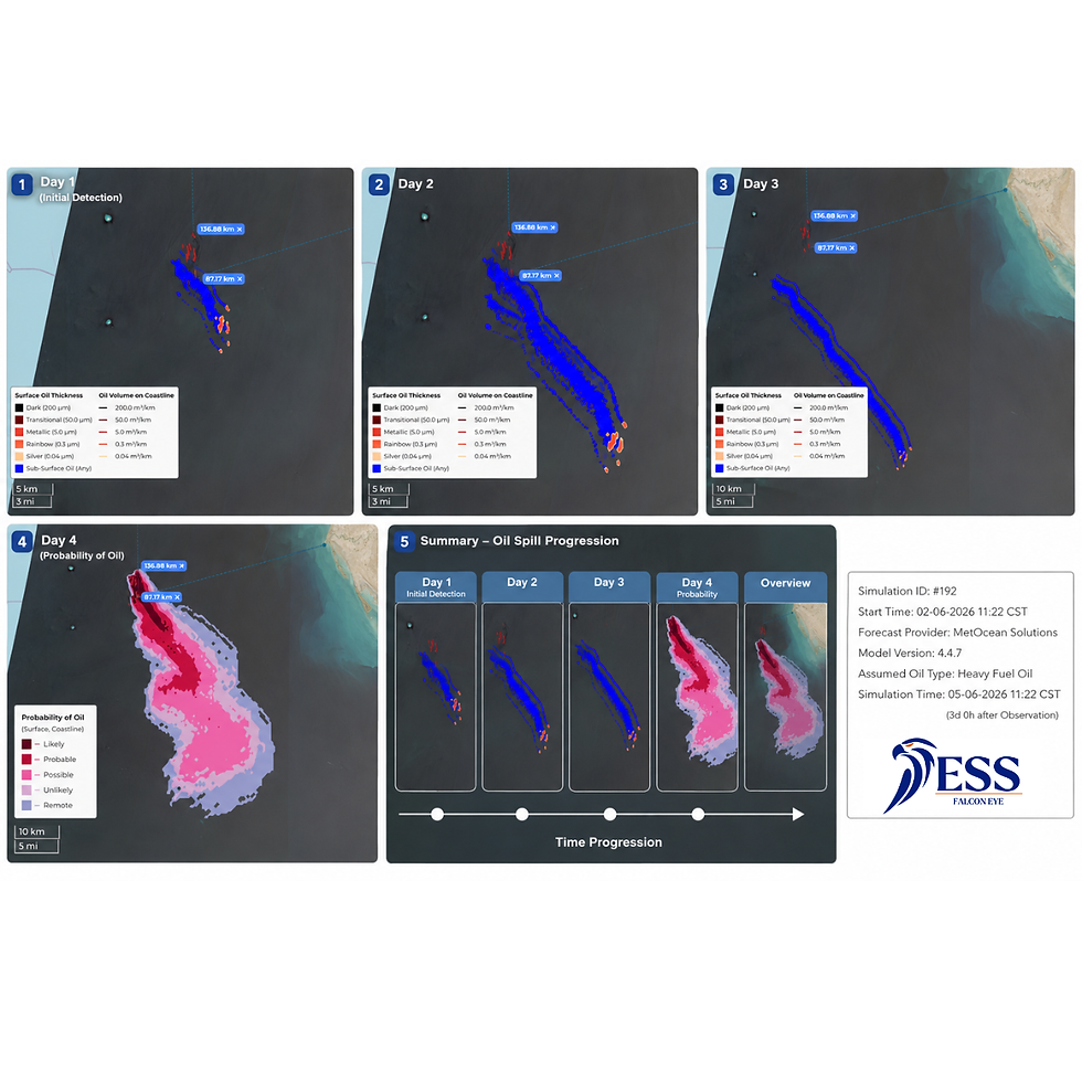
Our analytical workflow transforms raw satellite observations into structured operational intelligence. Every detected anomaly generates 24, 48, and 72-hour trajectory forecasts using both deterministic and probabilistic modelling. The deterministic model produces the single most likely spill pathway given current ocean currents, wind conditions, and wave data. The probabilistic model — built on Monte Carlo analysis — generates a full uncertainty envelope, identifying the range of possible outcomes including lower-probability but high-consequence scenarios that the deterministic run might not capture. Both models use GEBCO 2024 bathymetric data and account for oil weathering, evaporation, and emulsification behaviour.
The dispersion model underpinning this work has been independently validated by the Science and Technology Facilities Council's Hartree Centre using confirmed real-world incidents. The source attribution algorithm — which can correlate a detected spill back to a probable origin and cross-reference AIS vessel tracking to identify candidate vessels — was developed in collaboration with Oxford University's Pattern Analysis and Machine Learning Research Group. These capabilities are underpinned by independent validation and academic collaboration.
What Persistent Monitoring Actually Means
During our monitoring period, anomalies have been tracked approaching some of the Gulf's most critical maritime infrastructure. When trajectory modelling places a confirmed spill within the plausible 72-hour impact envelope of a major port, the operational implication is immediate: duty staff go to heightened readiness, environmental monitoring protocols are reviewed, and response resources can be pre-positioned rather than scrambled after the fact.
That is the practical value of persistent monitoring. Not a single dramatic interception, but a sustained stream of early warning that compresses response timelines, improves decision quality, and — crucially — allows authorities and operators to distinguish genuine threats from benign features before they commit resources.
The Gulf also generates significant natural look-alike signals: biogenic surface films from algae and plankton, ship wake turbulence, low-wind zones that mimic oil backscatter. Every report our analysts issue includes a confidence assessment. The discipline of stating what we know and what remains uncertain is not a limitation — it is the foundation of trust with clients who need to act on the intelligence we provide.
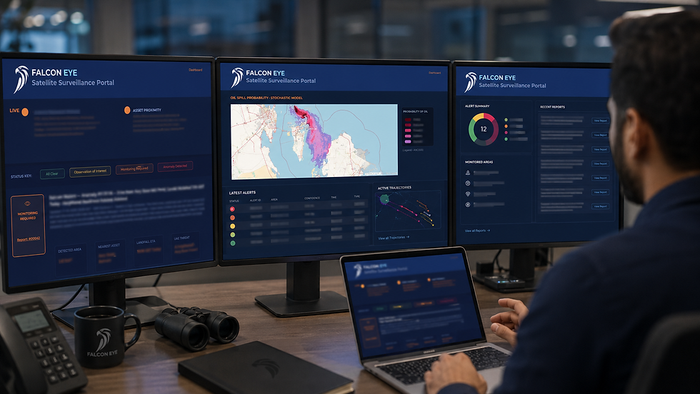
Central to the Falcon Eye service is a dedicated client portal, accessible from any desktop or mobile device. Rather than waiting for a scheduled report, operators can see the current alert status at a glance — updated as new satellite passes are processed and new analysis is issued. The portal provides an at-a-glance operational picture: current anomaly status, active trajectories, and the full report archive in one place. For a duty officer checking the Gulf situation at 06:00 before a vessel movement, or an environmental manager reviewing overnight developments, that immediacy matters.
The UAE's Blue Economy Deserves Blue-Water Surveillance
The UAE has committed at a national level to environmental stewardship, maritime safety, and the development of a sustainable blue economy. Abu Dhabi's port infrastructure, Dubai's maritime hub status, and Fujairah's position as one of the world's largest bunkering ports are not just economic assets — they are national strategic interests that carry environmental responsibility.
Satellite-based oil spill monitoring is not a luxury capability for governments with larger coastlines. It is the minimum standard of situational awareness that modern maritime infrastructure requires. When a spill is detected early, the environmental cost — measured in contaminated coastline, damaged marine ecosystems, and disrupted port operations — is orders of magnitude lower than when it arrives without warning.
Falcon Eye exists to ensure that UAE maritime operators, port authorities, and environmental regulators never receive that kind of surprise. We do not deliver data feeds — we deliver managed intelligence: analysed, modelled, interpreted, and issued by specialists who understand both the technology and the operational context in which it is used.
The Gulf Never Sleeps. Neither Does Falcon Eye.
Falcon Eye is a satellite surveillance and maritime intelligence service operated by Emergency Safety Solutions Ltd (ESS Ltd), headquartered at Masdar City, Abu Dhabi. For enquiries regarding oil spill monitoring, maritime surveillance, or environmental risk assessment services, contact: cj@ess-uae.me


Comments